Garmin GPSMAP 478 Color GPS

GPSMAP 478C

On land or water, you're ready to go

Go from box to boat to dash with the portable and versatile GPSMAP® 478. This combination color chartplotter and land navigator comes preloaded with U.S. marine charts utilizing elements of the latest BlueChart® g2 technology, in addition to detailed street-level mapping. Optional weather and sonar capabilities combined with the ability to conveniently add plug-in data cards, let you easily add more maps and features — making this one incredible GPS navigator for land and sea.

Preloaded and Portable

From curbside to dockside, the GPSMAP 478 has you covered — no downloads or computer required. Its built-in marine charts utilize the latest BlueChart® g2 technology and feature coverage for all U.S. coastal areas, including Alaska and Hawaii. Our g2 mapping technology offers a smoother, more fluid presentation on your screen.

For road trips, the 478 along with its freshwater counterpart, the GPSMAP 378, come preloaded with City Navigator NT detailed street maps for North America and include automatic routing with voice guidance along with an industry-leading database with more than six million points of interest — including hotels, restaurants, gas stations, marinas, attractions and more. An included marine mount and automotive kit make it a snap to transfer the unit from boat to car.

Up-to-date Weather
See real-time weather displayed on the 478’s high-resolution 256-color sunlight-readable TFT display with the purchase of the GXM 30 antenna (sold separately) and subscription to XM WX Satellite Weather. View vital weather data, such as NEXRAD radar, storm cells, wind speeds, surface temperatures, forecasts and more than a dozen other weather attributes directly on the unit’s display — so you can spend more time enjoying the water and less time worrying about the weather.

With the GXM 30 antenna, you also have the option of receiving XM Satellite Radio’s 150 plus channels of commercial-free music, sports, news, talk and entertainment programming. Weather and audio options travel with your plotter, whether you’re navigating on land or sea.

Sonar Capability

If fishing’s your game, pair the 478 with the GSD™ 21 remote sounder module to add sonar capability. The GSD 21 is Garmin’s “black box” sounder, which offers 4,000 watts of power peak-to-peak (500 watts RMS) in a dual-frequency transducer (purchased separately).

Plug-and-play Additional Mapping

Optional software available on plug-in Garmin data cards, lets you instantly add new maps to your GPSMAP 478 — without connecting to your computer. Easily customize map data for your adventures on land or sea with our optional MapSource® cartography. Plug-in the latest BlueChart g2 data cards to add “real picture” aerial photo reference, detailed coastal roads and points of interest. For inland coverage, try our preprogrammed U.S. Inland Lake data cards. See the MapSource Compatibility table (top right) for a list of software that Garmin recommends with this product.

The GPSMAP 478: Loaded and ready for action, right out of the box

GPSMAP 478 Features:
Pack # Garmin GPSMAP 478 Color - Select your package and add any accessories you want.
This item has been discontinued. The accessories listed below are still in stock.
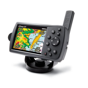
Everything we sell is purchased directly from the manufacture.


Package Accessories included with the 478 Color

GPSMAP 478C
Preloaded with U.S. marine detail maps (g2 technology)
Preloaded City Navigator® NT North America (full coverage)
Trip & Waypoint Manager
USB/PC interface cable
Power/data cable
Marine mount
Automotive mount
Universal friction mount (bean bag mount)
12-volt adapter cable with speaker
AC charger
Protective cover
Owner‘s manual
Quick reference guide