
|
|
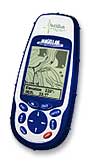
Package Accessories included with the Magellan Meridian Marine PC Interface Cable PN:730342 16 MB total built-in maps Secure Digital Memory Card slot Owner's Manual Quick Reference Card One Year Warranty Suggested Retail Price Our Price: $319.00 |
||||||||||||||||||||


Popular Accessories | ||||
Optional Accessories | ||||
| Part # | Accessory Description | Our Price | Purchase | |
| PRO99 | NiMH Battery Pack, click for more info b... | $22.00 | ||
| SPP02 | Dual Cigarette Adapter | $9.50 | ||
| 701239 | Meridian Series Swivel Mount Bracket | $18.00 | ||
| 701241 | Meridian series Vehicle Mount Bracket. | $34.00 | ||
| 701242 | Meridian series Bicycle Mount Bracket. | $28.00 | ||
| 701245 | Meridian series carry case | $9.00 | ||
| 730342 | Meridian/SporTrak series PC cable | $24.00 | ||
| 730343 | Meridian/SporTrak Series Cigarette Light... | $19.00 | ||
| 730344 | Meridian/SporTrak Series Power/Data Cabl... | $24.00 | ||
| 730345 | Meridian/SporTrak COMBO PC/Cig lighter c... | $34.00 | ||
| OTBOX9000 | Otter Box | $16.00 | ||
| 980614-01 | 8 MB Data Memory Card | $45.00 | ||
| 980614-02 | 16 MB Data Memory Card | $62.00 | ||
| 980614-04 | 32 MB Data Memory Card | $39.00 | ||
| 980614-05 | Meridian 64 MB Data Memory Card | $49.00 | ||
| 980611 | Magellan MapSend Topo | $78.00 | ||
| 980613-01 | MapSend Streets and Destinations US | $75.00 | ||
| 980635-05 | Magellan BlueNav CD Rom | $149.00 | ||
| 980599 | MapSend Streets Europe | $114.00 | ||