|
|
|
|

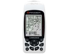
Lowrance iFinder Atlantis
 iFINDER® Atlantis
POWERFUL POCKET-SIZE
GPS-MAPPING/PERSONALIZED FACEOFFS® OPTIONS
Personal Favorites
| - |
Special for marine voyagers, includes
a 16MB MMC card preloaded with detailed mapping of continental U.S. coastal
and Great Lakes waters featuring over 60,000 critical navigation aids and
10,000 wrecks and obstructions. |
| - |
Comes with a unique white FaceOffs® cover. |
| - |
A
go-anywhere, comfortably lightweight, shirt pocket-size, full-featured
hand-held GPS/mapping receiver. |
| - |
Special
ergonomic contoured design promotes convenient one-hand operation. |
Performance Profile
| - |
Full
12-parallel channel GPS+WAAS reception with fast satellite locks and precision
tracking worldwide. |
| - |
Actual
size: 2.5" wide x 5.5" high x 0.9" deep (64 x 141 x 23 mm) |
| - |
Large 120 x 160
(w x h) resolution - 19,200 total pixels, high-contrast Film SuperTwist LCD
display; excellent map detail and readability especially in direct
sunlight. |
| - |
Backlighted
screen for high visibility at night or in low light. |
| - |
Menu
key for easy on-screen features selection. |
| - |
Simple
to use and understand, even for first-time navigators. |
| - |
Built
in slot for Multi-Media Card (MMC) data cards used for high detail maps (8-128 MB) |
| - |
Antenna port for connecting an optional external GPS+WAAS antenna (LGC-12W) |
| - |
Operates
on just two AA batteries1
with an advanced circuit design that extends battery life. |
GPS/Mapping
| - |
Built-in, exclusive, custom, Lowrance background map with special
waters/highways detail for the 48 contiguous states and Hawaii. Enhanced
detail on U.S. coastal waterways, lakes and rivers. |
| - |
Ultra-simple
point-and-map cursor navigation and route planning. |
| - |
Mega-memory
saves up to 1,000 waypoints and 1,000 event markers. |
| - |
10 savable plot trails up to
10,000 points per trail / stores up to 99 routes. |
| - |
42 different graphic icons to mark favorite spots. |
| - |
Map
zoom, 37 display ranges from 0.05 — 4,000 miles, with one-touch
zoom-in/-out control. |
For Your Protection
| - |
Uses
flash backup memory for data storage up to 100 years. |
| - |
Includes
waterproof travel pouch with adjustable neck strap; rugged, flexible,
transparent design provides unrestricted
reception-viewing-operation, and serves as a flotation device.
Without pouch, iFINDER® is water-resistant to IPX2 standards. |
| - |
Full
one-year warranty. |
Popular Options
| - |
MapCreate™
Accessories Pack includes CD-ROM software (see below), one 16MB MMC
digital memory card, and a PC-compatible MMC reader/interface with USB cable to create and
load custom mapping. |
| - |
Optional
MapCreate™ CD-ROM software2
allows for customized maps to exacting proportions.
Unique "cookie cutter" map chooser feature helps users to
maximize iFINDER® programmable MMC cards by allowing selection of
specific, detailed map areas for downloading. MapCreate™ details more
than 60,000 critical navigation aids and 10,000 wrecks and obstructions in U.S.
coastal and Great Lakes waters. |
| - |
MapCreate™
maps include searchable point-of-interest feature to easily find or
identify bodies of water, parks, cities, street intersection addresses, lodging,
restaurants, fuel and more, with ease of cursor placement or menu
selection. |
| - |
Easy-to-change,
optional FaceOffs® personalize iFINDER® to personal taste, in a choice of
five striking colors: red, blue, yellow, black and camouflage. |
| Pack # |
Lowrance iFinder - Select your package and add any accessories you want. |
| Pack #1 | iFinder Atlantis This package is shipped with the iFinder Atlantis, pre-loaded MMC card (featuring U.S. coastal and Great Lakes detail with navigational aids, obstructions and wrecks), white faceplate and the package accessories listed below. | Our Price $279.00
|
|
Package Accessories Included
iFinder Atlantis
Neck Lanyard
Waterproff Pouch
One Year Warranty
Owner's Manual
Quick Reference Card
|
|
