|
|
|
|
GARMIN programs electronic offshore G-charts using Navionics digital cartography to offer worldwide coverage. All offshore G-charts are digitized directly from existing government maps and other official charts. These G-charts display nav- aids, depth contours, port plans, obstructions, bottom conditions, fishing information, etc., for a specific area.
Do to the complex nature of G-charts, we ask you to venture to the Garmin website. You can find the G-chart you need by clicking the links below. When you find the G-chart number write it down and enter it in the space below and click "add to your shopping cart". You can use your browser's "BACK" button after you find the number to reload this page.
WE only accept G-Chart orders over the internet. Basically we want you to make sure the chart number is correct, one number off and you will get the wrong chart.
ALSO please make a note in the "Specail Instructions area" on the check out form (Just above your credit card number) as to what GPS system you have. The GPSMAP 180 and GPSMAP 185 use micro charts, the first letters are MGUS.... all other chartplotters use standard size chart cards. No difference in the data, just the physical size of the card.
Please contact Garmin Direct for G-Charts. We are no longer able to burn G-Charts.
|
|
 |
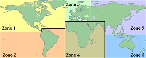
To view available offshore G-charts, select a zone from the list below.
|
|
|
Suggested Retail Price $299.99
Our Price: $279.00
|

