|
|
|
CANADA BLUECHARTS

| |
BlueChart |
Name |
Description |
|
|
CA001R
In Stock
|
Inside Passage |
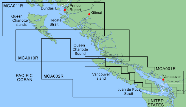
Detailed coverage of Queen Charlotte Strait and the Strait of Georgia from Bull Harbour, BC to Bellingham, WA, including Vancouver, Nanaimo, Powell River, and Courtenay, BC. General coverage of the west side of Vancouver Island from Lanz Island to Barkley Sound with detailed coverage of Quatsino Sound. |
|
|
CA002R
In Stock
|
Outside Passage |
General coverage of the Strait of Georgia and Queen Charlotte Strait from Saltspring Island north to the southernmost portion of Moresby Island with detailed coverage of Port Hardy, BC. Detailed coverage of the west side of Vancouver Island from Victoria, BC to Quatsino Sound, including Neah Bay, WA, Ucluelet, BC, Clayoquot Sound, and Nootka Sound |
|
|
CA010R
In Stock
|
Hecate Strait South |
Includes coverage of the southern portion of the Queen Charlotte Islands, Hecate Strait, Queen Charlotte Sound, and Queen Charlotte Strait. Includes detailed coverage of many areas including Port Hardy, BC, Burke Channel and Dean Channel. . |
|
|
CA011R
In Stock
|
Hecate Strait North |
Includes coverage of the northern portion of the Queen Charlotte Islands, Hecate Strait and Dixon Entrance from Duke Island to the northern portion of Aristazabal Island. Includes detailed coverage of many areas including Prince Rupert, BC, and the Grenville Channel. |
|
|
CA500L
Retail $212.49
|
Puget Sound to Port Hardy |
Detailed coverage from Puget Sound through the Strait of Georgia and Queen Charlotte Strait to Port Hardy, BC, including Olympia, WA, Seattle, WA, Victoria, BC, and Vancouver, BC. Primarily general coverage of the west side of Vancouver Island and northwest corner of Washington state from Grays Harbor, WA to Kyuquot Sound, BC. Included in this overall general coverage are a number of detailed charts covering areas such as Westport, WA, Neah Bay, WA, and Ucluelet, BC. |

| |
BlueChart |
Name |
Description |
|
|
CA004R
In Stock
|
Bay of Fundy |
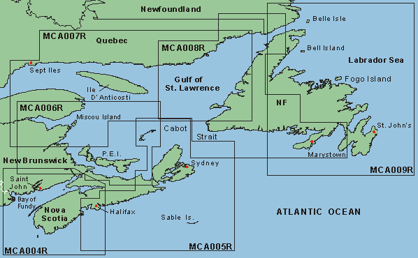
Detailed coverage of the coasts of Maine and New Brunswick from Machias Bay, ME to Saint John, NB. Also covers in detail the western half of Nova Scotia from Digby to Halifax, including Yarmouth. General coverage of the eastern half of the Bay of Fundy, extending to Chignecto Bay and Minas Basin. |
|
|
CA005R
In Stock
|
Halifax to Cape Breton |
Covers eastern Nova Scotia from Halifax to Sydney, around Cape St. Lawrence, and down to Antigonish, including Chedabucto Bay and St. Georges Bay. Also includes the Iles de la Madeleine to the north and Sable Island to the south. |
|
|
CA006R
In Stock
|
P.E.I to Chaleur Bay |
Covers Prince Edward Islandís coastline in its entirety. Also covers the coasts of Nova Scotia, New Brunswick, and Quebec from Antigonish, NS to Perce, Que., including Miramichi Bay and Chaleur Bay. Also covers the Iles de la Madeleine. |
|
|
CA007R
In Stock
|
Les Mechins to St. George's Bay |
Covers the coasts of New Brunswick and Quebec from Miramichi Bay to Les Mechins, Que., including Chaleur Bay and the Bay of Gaspe. Also covers the coast of Quebec to the north from Port-Cartier to St.-Augustin, including Sept-Iles and Havre-St.-Pierre. Also includes Ile díAnticosti and the St. Georgeís Bay area of New Foundland. |
|
|
CA008R
In Stock
|
Newfoundland West |
Covers the western and southern coast of New Foundland from the Strait of Belle Isle to Placentia Bay, including St. Georgeís Bay and Fortune Bay. Also covers the coasts of Quebec and Labrador from La Romaine to Red Bay. |
|
|
CA009R
In Stock
|
Newfoundland East |
Covers the eastern and southern coasts of New Foundland from St. Barbe to Hermitage Bay, including Bonavista and St. Johnís. Also covers the coast of Labrador from Forteau to Cape Charles. |
|
|


